The online racing simulator
Track Images (alternative to SMX files)
Hello programmers.

You may have seen Victor's new LFS remote spectator system : http://www.lfsworld.net/remote/

To help with that I made a new function to create large two dimensional image files from our track editor. The images are antialisased and show textured tracks just as they appear in game (excluding shadows) so these may be a better choice of data for some 2D-only programs that currently use SMX files. One pixel equals one metre. The LFS coordinate origin (x=0, y=0) is in the centre of the map. The size of all images is 2560x2560.

Here is a zip file of all tracks saved as lossless TIFF images. When you distribute them with a program you will probably want to compress them appropriately. We are providing them in a lossless format so you can choose the level of compression you need.

50 MB ZIP file containing TIFF images : (now includes Rockingham)
https://www.lfs.net/file_lfs.php?name=TRACKS_TIF.zip

9 MB ZIP file containing only the Rockingham TIFF image :
https://www.lfs.net/file_lfs.php?name=RO_TIF.zip

Compressed JPG images :
https://img.lfs.net/remote/maps/BL.jpg
https://img.lfs.net/remote/maps/SO.jpg
https://img.lfs.net/remote/maps/AU.jpg
https://img.lfs.net/remote/maps/FE.jpg
https://img.lfs.net/remote/maps/AS.jpg
https://img.lfs.net/remote/maps/WE.jpg
https://img.lfs.net/remote/maps/KY.jpg
https://img.lfs.net/remote/maps/RO.jpg
Hmmm the cleanest and clearest views of the tracks I've seen. These will come in handy not just for programming
Indeed, just got an idea. God, I don't have time to do this right now too. Damn you, and I love you all at the same time.
thanks very much... amazing
#5 - Stuff
Very nice! Although they are a little lower in resolution than I use in LYTe, they're still more accurate and look a lot better. I will definitely try to use them in my new version. Thanks a ton(ne)!
Not being one to moan, but is that the highest resolution you've got? I have no particular need for them as of this present moment, but I'm sure I could think one up
I have little need for them myself for any programming (cos I don't do any), but they will be useful for a few little purposes I have thought of.. You never know, I could get some printed as posters ... sheesh, that's a good use for those ink cartridges I nicked

Have an Emppu Vuorinen impersonating banana :bannana_g

James : I think the reason they are the size Scawen posted them is because IIRC Flash (what Vic's using) rolls over and dies if you feed it anything bigger.
Quote from duke_toaster :James : I think the reason they are the size Scawen posted them is because IIRC Flash (what Vic's using) rolls over and dies if you feed it anything bigger.

Oh I understand *why* they're this size, I'm just asking if he has any bigger ones
-
(wheel4hummer) DELETED by wheel4hummer
1
Quote from Fischfix :i am wondering why are the [FM] Servers not listet... we have 5 servers and two of them have people on it atm but its not listet...

a) Wrong thread. This one is about some pictures; not about the new relay flash
b) Probably because your server admin didn't add them to the relay on lfsworld.
#11 - sun
ye very nice!

but is there away to find out the co-oedinates for the tracks ?

for example if you hover your mouse over the map in the road for example, it tells you the co-ordiantes for that point ?
#13 - sun
What programm do i have to use for it to show the co-ordinates ?
Thank!! It is just what I need for a project im currently is making
Quote from JamesF1 :Oh I understand *why* they're this size, I'm just asking if he has any bigger ones

Does anyone have any high res images of the tracks (preferably BL1). Really want to print some out large scale...
Do you need the whole picture (which I don't have) or do you only need the track? In the latter case serve yourself with a svg-file:
http://cl.racemore.de/mpres/im ... L1_0.5Z28_km_all_1000.svg (1000 can be replaced the desired size, the other tracks are loaded the same way)
In case you don't want the "unselected configs" remove "_all" ... you can also replace km by mi ...
(At the moment tracknames are case sensitive, so please use uppercase only)
Hi Scawn
nice JPGs pictures. How did You render?
How did you manage the texturation of terrain?
Do you kow where to get the terrain Koordinates with textur koordinates.?

thanks
avetere, nice vector graphics.
But I was wondering where is the 0:0 in them and how to find the scale?
-
(PeterN) DELETED by PeterN : oops
Quote from Gutholz :avetere, nice vector graphics.
But I was wondering where is the 0:0 in them and how to find the scale?

Thanks!

0:0 is in the upper left corner, if that's what you mean. I'm not entirely sure about whatyou are refering to by "scale", but I just crop the entire viewspace (which has a maximum of 2560x2560) down to what is actually used. The coordinates of the single points are really based on this maximum scale and I just adapt the viewbox to the minimum and maximum values that are used (plus some extra space for a nice framing).

Did that answer your question?
Quote from avetere :Thanks!Did that answer your question?

Thanks for reply, but it did not
I will try to explain better.
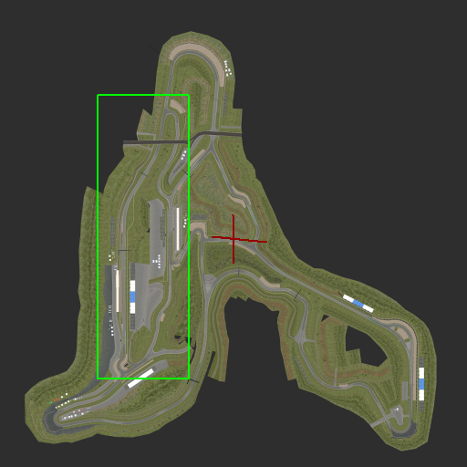
I want to convert the coordinates that LFS gives via insim into pixel-coordinates on your images.
For Scawen's image that is easy because 0:0 is the center of image and 1 pixel equals 1 meter:
red cross = 0:0 in "LfS GPS system"


(resized for forum)
So if a car is at 345:1040 it can be converted to a pixel position on the image.

[quote]I just crop the entire viewspace (which has a maximum of 2560x2560) down to what is actually used.[quote]Yes. But how excactly (in numbers) do you crop it?

For example in above picture, the green rectangle is roughly what your graphics show for AS2 config:


Where is the "LfS GPS" 0:0 on this image?
It is somewhere to the right side of track, but where excactly.
I am asking so can use the vector images for this: https://www.lfsforum.net/showt ... php?p=1825693#post1825693
What is 0:0 in lfs coordinates, is 1280:1280 in my svgs. Exactly speaking, lfs coordinates x and y are converted to X and Y:
X = 1280 + x
Y = 1280 - y
(all of them expressed as meters)

Those are also the coordinates that are used to place all objects, as I use that coordinate system for the viewbox.

What range is actually shown on the picture depends on whether the contents are higher than wide (h>w) or wider than high (w>h).
Having minx, miny, maxx and maxy as boundary limits for the contents (each of which being between 0 and 2560 as for the transformed coordinate system) and w and h for width and height we get:

h = maxy - miny
w = maxx - minx

now, what is shown on the image is the rectangle between:
if w>h:
topleft:
x: minx - 0.1w
y: miny - 0.1w - (w-h)/2
bottomright:
x: maxx + 0.1w
y: maxy + 0.1w + (w-h)/2

if h>w:
topleft:
x: minx - 0.1h
y: miny - 0.1h - (h-w)/2
bottomright:
x: maxx + 0.1h
y: maxy + 0.1h + (h-w)/2

This is done to always have a small border around the track (or the drivable part actually) itself. Thus it is also possible to have negative coordinates in the viewport, as for example in th AS2 picture.
Btw: I plotted you the center, which, as I said is at 1280:1280 as a circle here:
Attached images
Unbenannt.PNG
Ah ok! Thanks for taking time to explain.
Now I also noticed the viewBox= tag in the svgs.
You're very welcome
-
(vanopaniashvili) DELETED by vanopaniashvili
-
(bogdani.cojocaru) DELETED by bogdani.cojocaru
Quote from vanopaniashvili :Developers You Should Fix This Corner
http://postimg.org/image/ifbo2gqu9/

That would make for a pretty epic flowing section if they were connected with the same radius as shown.
1

FGED GREDG RDFGDR GSFDG