The online racing simulator
DLV Autocross Layout
Hi everyone !

I got a new entry on my LFS Layout, and as i want to do lot more and layout Square, i will post as much as i can here, so keep a eyes on it !
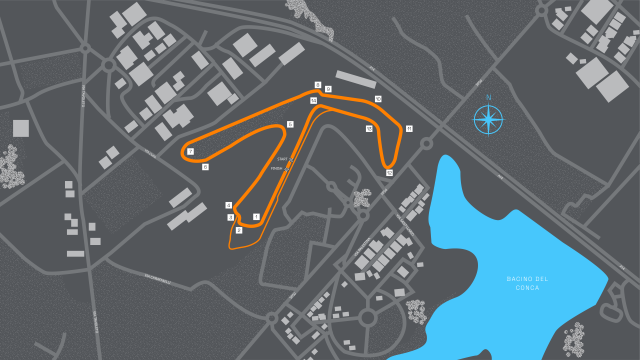
Misano E Prix


My first 1:1 track, heavy inspired by Michal layout for the e challenge. A reproduction of the layout that was used for the 2023-2024 double header in Italy ! 3.381 km of racing, attack mods is on, aswell as the new chicane ! You can also use the without chicane version if you want maximum speed. You can also use the alternative turn 12-13 for truck race.

A huge thank to Michal, Kova. and bruhmomento for the help !

A lap on the layout is here :


Have a nice day and take care Thumbs up
Attached files
LA1_MisanoEPrix.lyt - 23.8 KB - 92 views
LA1_MisanoEPrixNoChicane.lyt - 23.7 KB - 82 views
Hi everyone !

A new one, and a really good track, Indianapolis GP !


A 1:1 track made mostly on blender, with 40 pitbox/startbox, a real challenge ! Due to technical limitation, we avoid some oval part, but it's still a really great track even without ! Give it a try with a good Indy mods or a IMSA like car !


Have a nice day, take care Thumbs up
Attached images
Indy1.JPG
Indy2.JPG
Indy3.JPG
Indy4.JPG
Indy5.JPG
Indy6.JPG
Indy7.JPG
Indy8.JPG
Map.JPG
Attached files
LA1X_IndianapolisGP.lyt - 23.5 KB - 55 views
Next track to work is here..

Attached images
Capture.JPG
how u make the size & ratio correctly?
I think they use blender to put objects over a picture of the track, but I'm not sure
Quote from scania :how u make the size & ratio correctly?

Hi Scania. I use google earth to build the track. First i put a lot of line all accros what i need to build a track. When it's finish, i search somewhere where i can build a 90 degree angle, and with 2 line of 8 meter of distance, like some concrete. With this, i can easily import the google earth kml, who i convert to shp format, to blender. And i stretch anything until it fit 100%. After this, it's like play lego, put piece over and over..
Quote from THEFRENCHDESTOYER :Hi Scania. I use google earth to build the track. First i put a lot of line all...

for exemple with indianapolis :


I build yellow line, who is vector file around anything that i judge important. I prefer to do more than less, because it's easier to rebuild when you have exces of information. You can see a "curious" form on the finish line, it's a marker of 8x8m, that help me to have correct size. How i can be sure it's on the right size? Distance on track, and time to do the lap.

Hope i explain it on a good way Thumbs up
Attached images
indy2.JPG

DLV Autocross Layout
(8 posts, started )
FGED GREDG RDFGDR GSFDG